So it’s the third tremor I’ve felt while living in Darwin, almost 1 year now. Apparently there was one last night as well, around dinner time. That one I did not feel but perhaps I was busy, plus the tele was on, plus I’d had wine…
My bed shook at 5.46 this morning and something dropped on the floor in the apartment above me. Scared the proverbial …. out of me. Once I was awake enough to realise what it was (not Ian slamming the front door on his way to the airport) I rode the waves out in bed, quite calmly. I really enjoy such an experience, probably because I know exactly what’s happening, geologically speaking. I always try to focus for as long as possible to feel every wobble-cluster afterwards as they become gentler and fade away.
The ABC was quick to report this one, probably because it awoke most of Darwin, as well as some in Katherine. And they picked up my immediate comment off their Darwin Facebook page to stick in their article, as if they had interviewed me.
OK, so it’s a 6.6 up in the Banda Sea of Indonesia but what magnitude is it by the time we feel it in Darwin? And why are there so many earthquakes in the Banda Sea?
In Darwin, we really can’t describe the earthquake in terms of its magnitude, or size. Magnitude is a measure of the energy released at the epicentre of the earthquake. So because we’re some 700 km away from that point, we can only describe the earthquake’s intensity, or the amount of shaking we felt. There are heaps of factors that influence the intensity of an earthquake, like rock strength and depth of soil cover so, using the Modified Mercalli Scale, I’d describe this morning’s earthquake as a category MM4 – Largely Observed. MMI
I’ve found a great reference article which illustrates the actual shape of the sub-ducting Indo-Australian plate surface as it heads towards the (literal) centre of the Earth beneath the Eurasian plate.
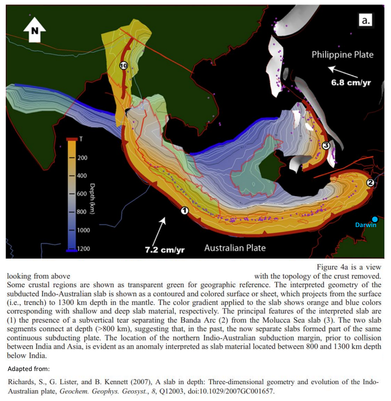
The geometry of the subduction zone is lovely and messy, as you can see from this picture. The Banda Arc (2) really takes a U-turn to the North of Darwin, hence all the little purple dots (which are Earthquake hypo-centres) follow parallel to the subduction boundary. You’ll notice the purple dots all sit about half-way through the orange zone of sub 200 km, which sounds about right given this morning’s earthquake was reported to have been ‘deep,’ at 177 km. Also, there was no tsunami warning, which is mostly the case for such deep earthquakes… it’s the shallow ones of less than maybe 50 km you have to worry about.
So, for us Aussies, the effect of losing ‘our land’ into the pits of the Earth at >5 cm per year could be described as us helping build Indonesia – but they have to put up with lots of earthquakes and a bunch of volcanoes as well.